Travel be safe and happy

Travel be safe and happy

Wednesday, September 1, 2021

Hikkaduwa in Sri Lanka


Hikkaduwa
 is a small town on the south coast of Sri Lanka located in the Southern Province, about 17 km (11 mi) north-west of Galle and 98 km (61 mi) south of Colombo.Hikkaduwa Sri Lanka is a beach city in Southwest part of the country, about two hours south of Colombo. It’s famous for beach resorts, giant sea turtles, scuba diving, moonstone mining, and being ground zero for the devastating 2004 Boxing Day Tsunami. Every year, more tourists come to Hikkaduwa and the industry is thriving. There is plenty to do in Hikkaduwa. A lot of these activities are good, but be you should prepare yourself. Some Hikkaduwa attractions are meh and some are outright ugly. That’s why we bring you Hikkaduwa Sri Lanka – the good, the meh, and the ugly

EXPLORING HIKKADUWA CORAL REEFS

Sri Lanka is famous for its coral reefs and the Hikkaduwa Coral Reef is located just outside the Coral Sands Hotel. You can bring a mask and snorkel from home or rent gear for cheap on the beach. Either way, we saw more tropical fishes in knee-deep water on the reef then we saw during our scuba diving trip. This is such an cheap and easy activity anybody who can swim owes  it to themselves to check it out if they’re ever in Hikkaduwa.


SCUBA DIVING IN HIKKADUWA

The reefs in Hikkaduwa claimed several ships and reasonable diving companies service local dive sites. We learned our lesson in Koh Tao and spent the little bit of extra money for Dive for You, which is on the grounds of the Hikka Tranz. They offered great equipment and excellent customer service.

The diving was good and definitely catered to experienced divers, unlike the turn and burn school we saw in Thailand. The diving was decent, but it wasn’t excellent. The vis was about 50’ and the sea life was present, but not abundant. In fact, a fishing boat set anchor at our dive site after we left. We did two wreck dives with reasonable hull integrity. My favorite part was clearly seeing the mast and rigging of an old sailing ship.


Flora and fauna

Foliaceous Montipora species dominate the coral reef. Encrusting and branching species are also present. Faviidae and Poritidae corals are contained in the inshore areas of the reef in massive colonies. Staghornelkhorn, cabbage, brain, table and star corals are all present in the reef.Corals of 60 species belonging to 31 genera are recorded from the reef. The reef also recorded over 170 species of reef fish belonging to 76 genera.

Sesagras and marine algae belonging to genera Halimeda and Caulerpa are common in the seabed depth ranging from 5–10 m. Seagrasses provide habitat to dugongs and sea turtles. Some species of prawns feed on the seagrass. Eight species of ornamental fishes also inhabit the reef, along with many vertebrates and invertebrates including crabsprawnsshrimpsoysters and sea wormsPorites desilveri is an endemic coral species of Sri Lanka. Chlorurus rhakoura and Pomacentrus proteus are two reef fish species confined to Sri Lanka. Blacktip reef shark are found along the outer slope of the reef. Three sea turtles which have been categorized threatened visit the coral reef: the hawksbill turtlegreen turtle, ad olive ridley

Kelaniya Raja Maha Viharaya .....


kelaniya 


           The kelaniya Raja Maha Viharaya is a Buddhist temple in kelaniya Sri Lanka.lt is located 11km north-east of Colombo. The main approaches of the vihara is the road that leads to Biyagama from the 4th mile of the Colombo-Kandy road. The sanctuary is sited on a higher plain ignoring the waterway Kelani that streams in front.

The temple has often been associated with the rise and fall of Ceylon / Sri Lanka, with the popular saying that as the Kelaniya temple rose, Sri Lanka rose and as it fell, the country and its administration fell. It has thus had a deep association with the political powers of the country.

It is also infamous for Mapitigama Buddharakkitha, the chief conspirator of the 1959 assassination of Ceylon's fourth Prime Minister S. W. R. D. Bandaranaike.Buddharakkitha was the chief incumbent (chief priest) of the Kelaniya Raja Maha Vihara from 1947 to 1959.


History

Buddhists believe the temple to have been hallowed during the third and final visit of the Buddha to Sri Lanka, eight years after gaining enlightenment.Its history would thus go back to before 500 BCE. The Mahawansa records that the original Stupa at Kelaniya enshrined a gem-studded throne on which the Buddha sat and preached. The temple flourished during the Kotte era but much of its land was confiscated during the Portuguese empire. Under the Dutch empire, however, there were new gifts of land and under the patronage of King Kirthi Sri Rajasingha the temple was rebuilt. It was refurbished in the first half of the 20th century with the help of Helena Wijewardana.

The Kelaniya Stupa enshrined a gem-studded throne on which the Buddha sat and preached. Lord Budhdha's second visit to Nagadeepaya, Sri Lanka was in the fifth year of enlightenment to settle a dispute between two Naga Kings, Chulodara and Mahodara over the possession of a Gem Studded throne. After having listened to the Dhamma sermons by Buddha the Naga kings paid homage to Buddha with overwhelming faith and the throne was offered to Lord Buddha by two Naga kings.

The temple is also famous for its image of the reclining Gautama Buddha and paintings by the native artist Solias Mendis which depict important events in the life of the Buddha, in the history of Buddhism in Sri Lanka, also incidents from the Jataka tales. It is the venue for the Duruthu Maha Perehera procession each January. An 18-foot stone statue of the Bodhisattva Avalokitesvara has been erected at the temple.


Tuesday, August 31, 2021

"Meemure" in Sri Lanka


Meemure is a village with a population of about 400.[1] It is located near the border between Kandy District and Matale District in the Knuckles Mountain Range. Meemure is one of the most remote villages in Sri Lanka with the only access via a 14 km (8.7 mi) trail from the town of Loolwatte.[2] There is no cellular service available in the village,[3] but a CDMA telephone service is available. There is no direct mail delivery to the village; a villager journeys each day to Thapal Junction to exchange incoming and outgoing postal mail with a postman.[3]Lakegala mountain is in Meemure village. Residents of the village depend on several staple crops including peppercardamom, paddy and ginger.[1] The distance from Colombo capital to Meemure is about 175 km.Meemure is approximately a 7-hour drive from Colombo, in an off-road vehicle. The main route is via Kandy city which is 116 km away from Colombo. Then Kandy-Mahiyangana Road (A26) towards to Mahiyangana. Turn to Left from Hunnasgiriya Junction which is 35 km away from Kandy. Then go towards the Loolwatte Village which is 15 km away from Hunnasgiriya Junction. Then from Loolwatte it is about another 15 km to the Meemure Village. The nearest Police station is Udadumbara Police.

On your way to Meemure from Colombo are a number of sites, including Hulu Ganga (River), Victoria Reservoir, Teldeniya New Town (Teldeniya was flooded in filling the Reservoir behind the Victoria Dam, Mahaweli Project), Dothalugala Forest and Botanical Garden, Mini Worlds End, Coberts Gap (Attala Mottuwa) a place where lot of wind blowing to the other side, Meemure and Lakegala Mountain where, according to legend, King Rawana lifted his Air Plane called Dhadu Monara.Meemure is approximately a 7-hour drive from Colombo, in an off-road vehicle. The main route is via Kandy city which is 116 km away from Colombo. Then Kandy-Mahiyangana Road (A26) towards to Mahiyangana. Turn to Left from Hunnasgiriya Junction which is 35 km away from Kandy. Then go towards the Loolwatte Village which is 15 km away from Hunnasgiriya Junction. Then from Loolwatte it is about another 15 km to the Meemure Village. The nearest Police station is Udadumbara Police.

 Meemure is an isolated village in the Central Province of Sri Lanka, located 324m above sea level and hidden amongst the mountains. The only way to reach it is from the  ‘Hunnasgiriya’ mountain, which is part of the Knuckles range, approximately 50km from Kandy. It’s a difficult trail of 33km from Hunnasgiriya to Meemure with many tricky spots, though the view along it is excellent. The village itself receives abundant water in the form of waterfalls that have their sources in the evergreen forests of the Knuckles. East of the village lies the pyramid shaped Lakegala mountain; while the west is dominated by the picturesque Knuckles range. The northern boundary of Meemure borders a forest which runs to the ‘Pitawala Pathana’ grassland; and the south is bounded by Heen River.

Pack-bulls used to be the solitary method of transport to Meemure until 2004. Herds of cattle carried sacks full of goods and equipment to the village. Due to the fertility and prosperity of the village; the pack-bulls were only used to carry salt, cloths, tobacco and calcium bicarbonate. But with the invasion of modern technology, the trails have been widened to allow three wheelers, jeeps and small trucks.

FOLKLORE AND HISTORY

Meemure received its name from the ‘Mee’ trees (as the villagers called them) that surrounded the place.

According to the folklore the village dates back to almost 5000 years ago. Lakegala that that lies to the east is believed to have been the property of the legendary King Ravana from the Indian literary epic Ramayana. As the stories go, Lakegala was used by Ravana as a power source and there was a tunnel through Lakegala in the times of Ramayana. It is said the tunnel was sealed after the war of Ramayana with the corpse of Ravana placed within it.

Another story states dates to 700 B.C which was the era of King Vijaya who is believed to be the forefather of the current population of Sri Lanka. Vijaya arrived on the island from India with his followers and caught sight of the shapely primitive woman Kuweni. He was overtaken by lust and took Kuweni as his informal wife. Kuweni bore him two children, but then Vijaya banished her from his castle when he formally married a royal princess from India. Hence Kuweni was forced to take her move into the forest along with her children. It is believed that they lived in the forest where Meemure is located, and that the indigenous people of Sri Lanka originated from the two children of Kuweni. The indigenous people of modern Sri Lanka are based just 60km from Meemure in Mahiyanganaya; and seem to prove this belief to be the truth.

During the 16th century AD Sri Lanka was invaded by Portugal. The invasions continued through the centuries as the Dutch and English nations conquered the country subsequently. The annals of history state that the people of Meemure supplied saltpetre (potassium nitrate) for the gunpowder used by the Kandyan kingdom in their efforts of resistance. The cave that the saltpetre was (niter) was mined from still exists to this day.

During the same era, King Sri Wickrama Rajasinghe is said to have banished his daughter with a group men, one of whom he believed his daughter was having an affair with, to the village of Meemure. This solidifies the claim that Meemure in existence at the time.

BIO DIVERSITY

  • Meemure spans an area of 700 acres with Heen River passing through it.
  • Ravana Ella Falls also lie within these lands, fed by a stream from the eastern slope of the Knuckles.
  • The network of streams that run through Meemure,  originate from the Knuckles; and are home to over 25 species of freshwater fish, of which 8 are endemic and 7 nationally threatened.
  • The vegetation is typical to the Knuckles region and ranges from lowland semi-evergreen forests to Montana forests.
  • There have been over 130 species of birds recorded in the area, with approximately 10 migrant species and 20 endangered ones.
  • Out of the 20 species of Amphibians that have been seen in the wilderness, 12 are endemic and are considered nationally endangered.

LIFE IN THE VILLAGE

The village has a population of approximately 400 with about 125 families. The architecture is one of the main identities of Meemure. The villagers build eco-friendly homes using clay and illuk (spear grass) which lasts for over three decades. But the most unique aspect of their buildings are their boundary walls made of quartz.

Before cardamom cultivation was banned in 1982 due to the Forest Preservation Act, Meemure villagers earned their bread by harvesting the spice. After this they shifted to chena cultivation, paddy cultivation and pepper cultivation.

Nowadays some of the peasants earn their living by taking care of jaggery palms, which produce toddy and treacle. The village has one tiny village shop where the locals buy necessities such as salt and sugar; and no cable telephone or mobile network signal. The village does have CDMA telephone services, though, to some extent.

The villagers don’t have direct mail delivery to the village, either; and have to journey to Thapal Junction each day to exchange incoming and outgoing post with the postman.

NEARBY ATTRACTIONS

  • Lake gala

Lakegala is a mysterious looking pyramid mountain that is 1314m tall. The mountain bears many unmarked ruins, including caves with evidence of ancient human inhabitation. Some of the other attraction in the Lakegala region are Nawathna Waterfall, Ravana Falls and hiking trails in the deeps of Lakegala.

  • The village of Gala Muduna

This remote village lies south of Meemure and has just 20 families. Mostly untainted by the outside world; Gala Maduna has only a single junior school. As such, the villagers only learn up till they are 14 years old. The place is so remote that when people get sick they are taken to the hospital in a sling made of a sack tied to two sticks; and there is no telephone service at all. The trail to the village is rich with flora and fauna of the Knuckles ecosystem. The village itself gains its name,Gala Muduna, due to its being situated on a top of a large rock.

  • Heen Ganga

There are three major rivers that originate from the Knuckles and pass through the region; Heen Ganga, Hulu Ganga and Kalu Ganga. Heen ganga, in specific, begins from eastern slopes of the Knuckles range; flows approximately 36km through Corbett gap and Kalupahana; an finally joins the Mahaweli, the longest river of Sri Lanka. Ancient forests and diverse rocky plates line its banks. However, the Match Box Bridge. Here lies a veritable paradise of tinkling water falls, caves, and vibrant nature. This part of the river is also home to Bulath Happaya, an endemic species of fish. The only home within this stretch of land belongs to an elderly man called Heen Banda. He is often happy to have vistors, and will share his experiences and life story.

'' failed to upload. Invalid response: Unexpected token U in JSON at position 0
Uploading: 291950 of 291950 bytes uploaded.


Monday, August 30, 2021

"Fatna Burusgala Tourist Zone" - Deniyaya,matara

"Fatna Burusgala Tourist Zone" - Deniyaya,matara


This place is located at a distance of about 7km from Deniyaya in the Southern Province with amazing topography.
Really a great creation of nature

 This is called here

As "Patna Burusgala Tourist Zone".
From Deniyaya Green Town, take Viharahena Road, take the Enasalwatta Road to the left at the junction with Sisila Ima Resorts, and past the Patna View Point, you will enter a leafy shed with a bend.
The Kotapola
 Pradeshiya Sabha has set up a ticket for Rs. You can get to this amazingly fun as well as risky place with a 50 ticket.


This place has managed to attract a lot of tourists
(Experience at "Leisure world" in Kaluaggala)

 Because of the experience you can get from a place that grows naturally here. Many people are drawn to the Burusgala tourist area to experience the slippery waters of Burusgala.

It's really a life experience


Some places are at risk. This is because there is no guarantee of safety for bathers here. This is because of the possibility of a rock, hand, foot, head or any part of the body of someone slipping on the brush. But with good self-confidence and good focus, you can avoid accidents by engaging in these activities.😍👌

*friends is a once-in-a-lifetime experience😍👌 

 Patna Burusgala is located on a part of the Gin River which starts from Sinharaja. Having a very cool climate naturally creates a pleasant feeling in the body. It is the duty of all of us to preserve this wonderful ecosystem for future generations.

Go there at least once and experience that inspiration.

Warning 🚯️: As tourists we have a duty to keep such valuable places clean without polluting them.


"Aradunu Ella" - Badulla Srilanka

 "Aradunu Ella" - Badulla Srilanka


Aradunu Falls is a must visit place in Madolsima. This is a note about that waterfall. Turn left at Madolsima Junction on the Badulla-Bibila main road in the Passara Electorate in the Badulla District and go 4KM on the Madolsima Road. A tourist guide board with a photo is mounted on the side of the road and you can easily reach this waterfall after going 3KM on the road to the left from there.


"Laggalla ella", which originates in the Namunukula Range, forms the waterfall and forms the waterfall.
This waterfall flows through the tea estates of the "Kitul Kele" which is a clearing ground for the plantation industry. Several legends have been built around this waterfall. Another legend says that King Ravana hid Goddess Sita in this place.

Currently, a small power plant is being built across the falls to generate electricity for a private tea factory and several nearby official quarters.

The road is not difficult so you can easily reach the falls even without a tour guide.

According to the Sri Lanka Waterfalls Forum, the 88th largest waterfall in Sri Lanka is another hidden beauty in Uva.

Warning 🚯️: As tourists we have a duty to keep such valuable places clean without polluting them.


Comment #Share ☑️


#Aruduna_Falls


A visit to Madolsima is a must visit.


After reaching 4KM from Madolsima Junction on the Badulla-Bibila main road in Passara electorate in Badulla district, the road to the waterfall can be reached. The falls can be easily reached after 3KM.


Loggalla Oya, which originates from the Namunukula Mountain Range, created this waterfall and flowed into it. Because of the shape of the hill, this falls is called "Aruduna Falls" and is also used as the "Arjuna Falls" in the Tamil pronunciation.


This waterfall flows through the Kithul Kale Tea Estate which is a clearing paddy field for the plantation industry. Another legend says that King Ravana hid Sita Devi at this place.


At present, a small power station has been built across the waterfall to generate electricity for a private tea factory and several official residences.


The road is not difficult to reach and the falls are easily accessible even without a tourist guide.


According to the Sri Lanka Waterfalls Forum, this waterfall is the 88th highest waterfall in Sri Lanka.


Warning🚯️: As tourists we are

 It is our duty to keep our places clean and free from contamination.


#Comment #Share ☑️


Nine Archbridge -Srilanka

 Nine Archbridge 


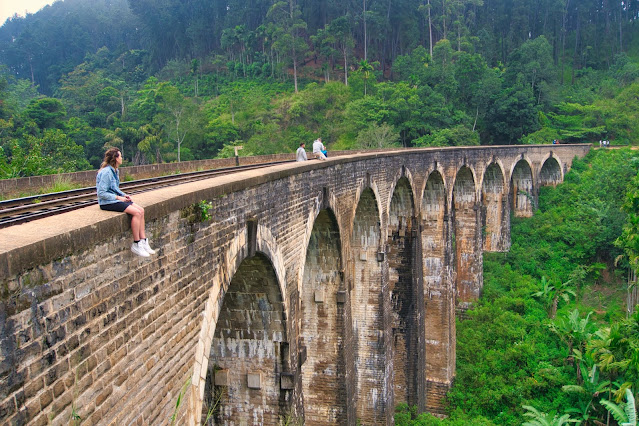
Built at 3100m above sea level, among the craggy peaks of the Central Highlands; the Nine Arches forms a viaduct between the Demodara and Ella Railway stations. Built entirely out of brick, rock and cement; without a single piece of steel; the bridge has stood solid from 1921, its time of creation. According to history, the bridge was built by the locals using such materials; when the construction came to a standstill from the lack of steel caused by World War I. But, in addition to this history; lore abounds the creation of the bridge.


The most famous story speaks of a man named P. K. Appuhami, who lived in the Kappatipola area in Melimada. Born in 1870, Appuhami was a famed traditional drummer and devil dancer (a ritual dance form). One day, while returning home gloomily as he lost a competition, Appuhami was seen by a British official. The man was extremely frightened by the devilish apparition (Appuhami was still in his dance costume) at the beginning; but soon became quite friendly. Learning that the strange foreigner was in his area to construct a railway; Appuhami assisted by supplying him with labour from the local villages.


But things did not go smoothly with the railway construction. They found that they were unable to bridge a large gap between two hills; as there was a quagmire in the valley in between. It was not possible to create firm anchoring, due to the marshy ground. On learning this, Appuhami requested to take over the bridge project. While he was rejected initially, they agreed later; as he had gained their trust with his assistance and friendship. As the story goes, Appuhami started working on the bridge in 1913. He solved the issue of the unstable ground by toppling giant rocks into the space; until a firm bed of rocks was formed. He then created the bridge’s brick columns over this bed and continued with the construction of the bridge.


The methods of constructions used by Appuhami proved to be so intuitive and cost effective; that he finished the entire project, which was intended to continue for many years, within a single year at a fraction of the original cost planned. The British officials were so shocked that the ‘savages’ had finished such a huge project so easily; that they refused to believe its structural integrity. At this point Appuhami is said to have sworn to the strength of the structure by saying he would prove it by lying under the bridge; when the railway line was used for the first time. Once the track was completed, he kept to his promise; awing the officials with his achievement.


Most interestingly, the story also states that Appuhami was then offered payment in the form of the balance costs that he saved with his inexpensive construction methods. The folklore speaks of the happy day when Appuhami returned to his village with four carts of silver coins. He then proceeded to spend it on meals for his village and the neighboring village for an entire two days, while also giving each villager a silver coin.


Regardless of the truth of the stories; the fact remains that the Nine Arches Bridge, with its nine graceful arches and solid construction, is one of the proofs of Sri Lanka’s skills in


Nine-Arch Bridge in Ella; Everything You Need to Know

One of the highlights in the mountain village Ella is the 30-meter high Demodara Nine Arch Bridge. With a small 30-minute walk through the jungle, you will reach a piece of beautiful architecture that is hidden between lush green tea fields. It is allowed to walk on the bridge and it’s one of the things you must do in Sri Lanka.

Stone bridge Ella

The stone train bridge, built by the British, with its nine beautiful arches, is located between Ella and Demodara station. The train ride in the highlands with the Kandy to Ella train is named as one of the most beautiful train rides in the world.

How to get to the Nine Arch Bridge

You have multiple options and ways to reach the train bridge. Follow the road towards Little Adam’s Peak and turn left at the small colored temple. Follow Lake Front Cottage on Google Maps.

 For a more quiet walk in between the jungle, turn left into the jungle at the parking spots after Art Cafe Umbrella. From here, you have to follow the path for about 10 minutes which gives you a unique view over the bridge. We highly recommend this path.

The quickest way is to walk along the track from Ella town until you reach a tunnel. After passing the tunnel, you immediately reach the Nine Arch Bridge

The easiest way to get to the Nine Arch Bridge is by a 300 LKR (2 USD) tuk-tuk ride from Ella. To save time, ask them to drop you off near the tunnel and walk to the bridge the last piece.


Train times at the Nine Arch Bridge

Trains pass the bridge about 6 times a day. The exact times change all the time in Sri Lanka but there should be one every hour. Don’t worry that you have to wait that long. It’s a great place to photograph and there are small cafes where you can buy drinks and food. We recommend you to get there in the morning, around 9 AM.

Do ask your guesthouse or hotel about the current train times.

Best time to visit the Nine Arch Bridge

Sunrise is the best time to visit the Bridge. The light is stunning and you avoid the crowds. By 10 AM, it is getting more busy with tourists since it is the start of their day trip tour.


Staying at Nine Arch Bridge in Ella

Over the last few years, more and more guesthouses have been opened or are still being built. It’s a little bit out of Ella town, so you need transportation to go to the popular restaurants. Nevertheless, waking up with a view of the Nine Arch Bridge is, without a doubt, a fantastic experience. These are the recommended hotels near the Nine Arch Bridge.


Ambuluwawa Tower


Ambuluwawa is a biodiversity complex and Sri Lanka's first multi-religious sanctuary situated in the central highlands of the country.

Distance from Kandy – 25.2 km (1 hour 10 minutes)

Ambuluwawa is a biodiversity complex and Sri Lanka’s first multi-religious sanctuary situated in the central highlands of the country. The Ambuluwawa Trigonometrical Station, in Gampola, consists of large winding tower resembling a stylized Buddhist stupa, a Hindu kovil, a Muslim mosque and a Christian Church. It is situated about 5 km from Gampola’s town centre.


Ambuluwawa Tower

Reaching the top of Ambuluwawa one can experience the most amazing views which could sometimes be covered by the ongoing mist. However, once the mist clears off the view can be scary and freak out climbers, especially those who have a fear of heights. Do note that hiking Ambuluwawa is not at all dangerous or risky, but it would not be the ideal kind of adventure for those with a fear of heights. Avoid leaning on the railing to capture photographs especially at the top as this is extremely risky and one could easily slip off from here. Ambuluwawa is a relatively easy hike to do which gives you 360 degree views of the surrounding mountains, forests, rivers and towns.


It is an area richly diverse, with evergreen forests, blossomed flower plants as well creepers and about 200 different kinds of plants from 80 plant families including a variety of medicinal plants. Ambuluwawa is surrounded by many mountains including Piduruthalagala from the East, Bible Rock (Bathalegala) from the West, Sri Pada (Adam’s Peak) from the South and Knuckles Mountain Range from the North. Apart from these mountains many other mountains are also clearly visible from here and adds to the beauty of the area. These are the Hanthana Mountain Range, Hunnasigiri Mountain and mountain ranges associated with Algalla and Kadugannawa. There is a cool mountain breeze in the area due to this reason.


The Ambuluwawa Hill and the adjacent forest is designated as a forest reservation which is named as the Ambuluwawa ICC Forest Reservation. The history of the Ambuluwawa Temple dates back to the 13th century during the reign of King Buwanekabahu IV. It is said that the Ambuluwawa Peak was the center of the Gampola Kingdom during his reign. But there is nothing with historical or archaeological values in here.


Ambuluwawa Tower Height

Ambuluwawa is situated approximately 1,965 feet from the level of Gampola town. The Ambuluwawa Mountain stands approximately 3560 meters above sea level. The tower stands at a height of approximately 48 meters and the elderly and kids are not recommended to climb to the top of it. The mountain road runs along the serpentine surrounded by mountain landscapes, cliffs and unique plants, which cannot be found anywhere else. Interesting places to visit include three ponds, a sacred Bodhi tree, water Park, stone Park and garden of herbs.


The Ambuluwawa Biodiversity Center was inaugurated by Sri Lanka’s former Prime Minister, Dissanayake Mudiyanselage Jayaratne, popularly known as “Di Mu”, who was born near Gampola. For those going from Colombo, Ambuluwawa is situated 85 km from the capital city. From Kandy take the Colombo – Kandy Road and go past Peradeniya and Gelioya up until you reach Gampola. Take the Ambuluwawa ICC Road to reach Ambuluwawa Trigonometrical Station.